While in Hue, we took a day trip tour of Vietnam's former demilitarized zone (DMZ), which, during the height of the Vietnam/American war, was actually quite the opposite of demilitarized. Running east-west basically along the length of the Ben Hai River... it was the highly militarized on either side, stripped bare of vegetation by defoliants and pitted by land mines and bomb craters. Our tour started in Dong Ha, the northernmost town south of the DMZ, in Quang Tri province.
We took a car from Hue, stopping briefly at Long Hung Church, a burnt out and bullet-riddled skeleton of a Catholic church that was the site of a battle between the North Vietnamese Army and the U.S. and South Vietnamese soldiers. The church is preserved as is by the Vietnamese government:


After that, we picked up our guide, Mr. Vu at Annam Tours, who is a Dong Ha resident and a Vietnamese military history expert, having studied the French and American wars at university. He was extremely informative, particularly if military history is your thing (sometimes I got a little bit lost in/overwhelmed by the numbers and strategy... but by the numbers seemed to be how the war was tracked... number of bombs, number of hills taken and/or lost, number dead).
Mr. Vu let us know that, like most Vietnamese, his family was heavily involved in the war on both sides- his father was conscripted by the South Vietnamese Army and he lost 5 relatives in the war to both sides. He also explained to us how his home province, Quang Tri, because of its strategic location during the war and the many battles fought in the area, is still to this day plagued by dangers left over from the war... unexploded ordnance such as landmines, artillery projectiles and mortar rounds have killed over 7,000 people in the province since 1975 and maimed thousands of others. Now Quang Tri is largely reforested or planted with coffee, rubber or cassava, but it remains the poorest province in Vietnam.
Once on our way, we headed west on Route 9, which was a road constructed by the French in the early 20th century and widened by American Army Corps of Engineers because it ran parallel to the DMZ and served as a major supply route for the bases that the American military built along side it. The road basically runs from Dong Ha all the way to the Laos border, crossing over the Ho Chi Minh trail.
Off the side of Route 9 we were able to see the location of the former Camp Carroll, a strategic Marine Corps artillery base early in the war and the Rockpile,
a large outcropping of rock accessible only by helicopter, which served
as a major observation point and long-range artillery base for the U.S.
Army and Marines during the war because of its height relative to the
surrounding area:
 |
| Former site of Camp Carroll (I think). |
 |
| The Rockpile. |
Further west on Route 9 we reached the Dakrong Bridge, which is where Route 9 intersects with the Ho Chi Minh Trail (now Ho Chi Minh Highway). The Daknrong bridge was hotly contested during the war because it was a major access point to the Ho Chi Minh Trail. It was blown up and rebuilt several times, but the current iteration was built in 1975 after reunification.


Plaques mark the bridge and Ho Chi Minh trail in remembrance of its importance during the war. The system of trails served as the major conduit for soldiers, supplies, weapons and ammunition heading from North Vietnam through Laos and Cambodia to South Vietnam during the war, and a major source of frustration for the U.S. military.


After the bridge, we headed to Khe Sanh, a former U.S. Marine Corps outpost and airstrip... now a museum, it was the site of a major 77-day long battle in 1968. Sitting atop a hill surrounded by several other hills on which U.S. troops were posted, the battle was long and bloody, with constant ground attacks, artillery fire and over 100,000 tons of explosives dropped in the region. Some people think, however, that the battle was just a diversionary tactic by the NVA, meant to preoccupy and distract General Westmoreland from the Tet Offensive, which began a week after the seige at Khe Sanh started... some say Westmoreland and President Johnson both became almost obsessed with maintaining Khe Sanh, not wanting it to become another Dien Bien Phu. Ultimately, later that year, all of the U.S. troops stationed at Khe Sanh were redeployed elsewhere and the base at Khe Sanh was abandoned (after everything there was blown up, trucked out or buried).
Our guide said cloudy/foggy weather such as this made the battle at Khe Sanh extremely difficult because low visibility prevented the surrounding hills from being able to see the base:

Now, the former base in the site of a museum full of photos and propaganda (the majority of which focused on the American withdrawal from Khe Sanh), some reconstructed bunkers and a collection of American military aircraft from around the country. It's very eerie and quiet, a far cry from what it was in 1968. The former highland base is surrounded by coffee plantations now and vendors at the site try to alternatively sell you coffee or war paraphernalia like medals and pins...


The former airstrip at Khe Sanh:

Tim in front of a big USAF supply plane:


Some of the thousands of unexploded bombs gathered from the region... it's estimated that over a third of the millions of tons of ordnance dropped by the U.S. during the war didn't explode:

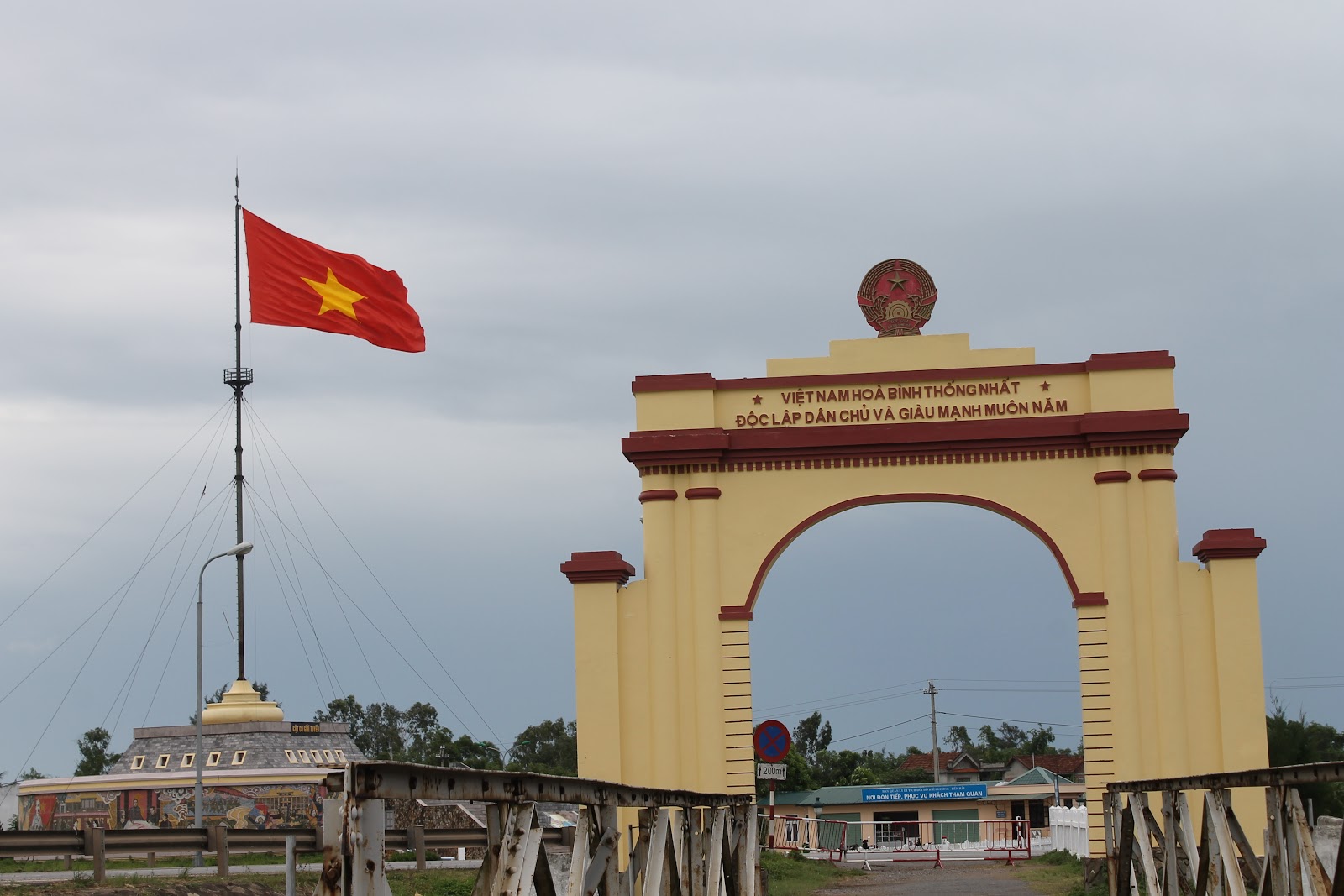
After Khe Sanh, we drove back on Route 9 towards the Ben Hai River/line of demarcation. The bridge in the photo is the Hien Luong Bridge- the new version is on the left and the older footbridge is on the right.
The bridge runs north/south across the Ben Hai River and bisected, half controlled by North Vietnam, half by the South. Our guide told us a story that the bridge started out painted 2 different colors, red on the north side and yellow on the south, but that, in the middle of the night, the North Vietnamese would paint their half to match the south side, then the south side would repaint a different color and the following night the North Vietnamese would repaint their side to match, etc. etc. He said that the North Vietnamese were trying to symbolically show that they wanted Vietnam to be reunited, that the Vietnamese were one people...
On the south side of the bridge, where I took this shot, there is a sign indicating where the South Vietnamese flag used to be located. You can see the corresponding flag across the river. Apparently there was also an ongoing flag-pole height battle between the two sides, each trying to build a higher flagpole.

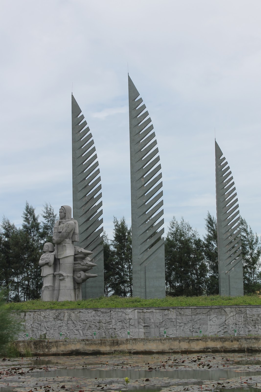
On the south side there is a large reunification monument with stylized palm leaves... the monument is called "Desire for National Reunification," and depicts a woman and child facing north, looking after her husband who crossed into the north in the months after the Geneva Conference, in the hopes that there would soon be elections that would unite the country again (although many more people moved from north to south during that time... those who lived in the south but sided with the communists were encouraged to stay south to fight in case the elections did not go their way... and fight they did).


We cross the bridge on foot and looked back at the monument from the northern side:


On the north side, there were a large set of speakers displayed... this represented the war of sound (like the flags and the bridge painting) that went on at this site. Propaganda and radio programs were blasted across the river towards the south 24 hours per day, prompting the other side to respond with bigger speakers and so forth and so on...

In the museum on the north side of the river, Tim stands in front of a flashy map of the DMZ, running from the coast all the way to Laos:

Next, we headed through miles of rubber plantations to Vinh Moc, where we were able to walk through a series of tunnels built during the war to shelter a heavily bombed coastal fishing town that lay within the "D"MZ. Americans believed that the village (just north of the DMZ) was supplying the North Vietnamese Army, so it was heavily bombed in order to force the villagers to leave. However, instead of leaving, the villagers (perhaps encouraged by the Viet Cong), in the mid-'60s, hand-dug a 3-level, 30 meter deep, 2 km long muddy tunnel complex under the clay soil, complete with "homes" for over 60 families, a large meeting rooms, and even a maternity unit in which 17 children were born. The entire village went underground and was continually bombarded by American bombs both from land and from sea for years until 1972.
One of the 12 entrances to the tunnels (since fortified, but originally just a clay opening):

Some trenches dug near the tunnels for moving supplies:


A hole blown in the tunnels by a U.S. "drilling bomb" (designed to burrow down 10 meters) that failed to explode... no one was injured and the hole served as a ventilation shaft for the tunnels:

This local villager was hanging out by the tunnels, staring out at the sea from inside the bamboo forest:

Our guide, standing next to some of the ordnance that was dropped in the area during the war:

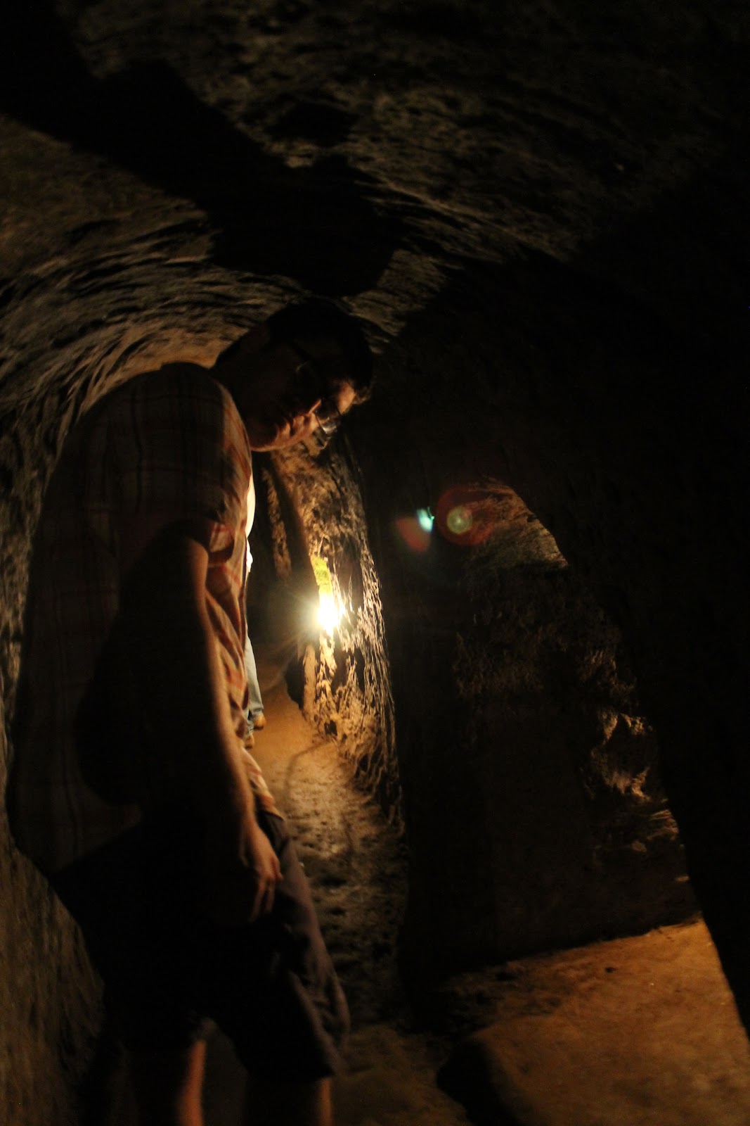
Tim and our guide entering the tunnels... watch your head!:


The tunnels are now illuminated (sorta) by electric lights, but that was not the case during the war:


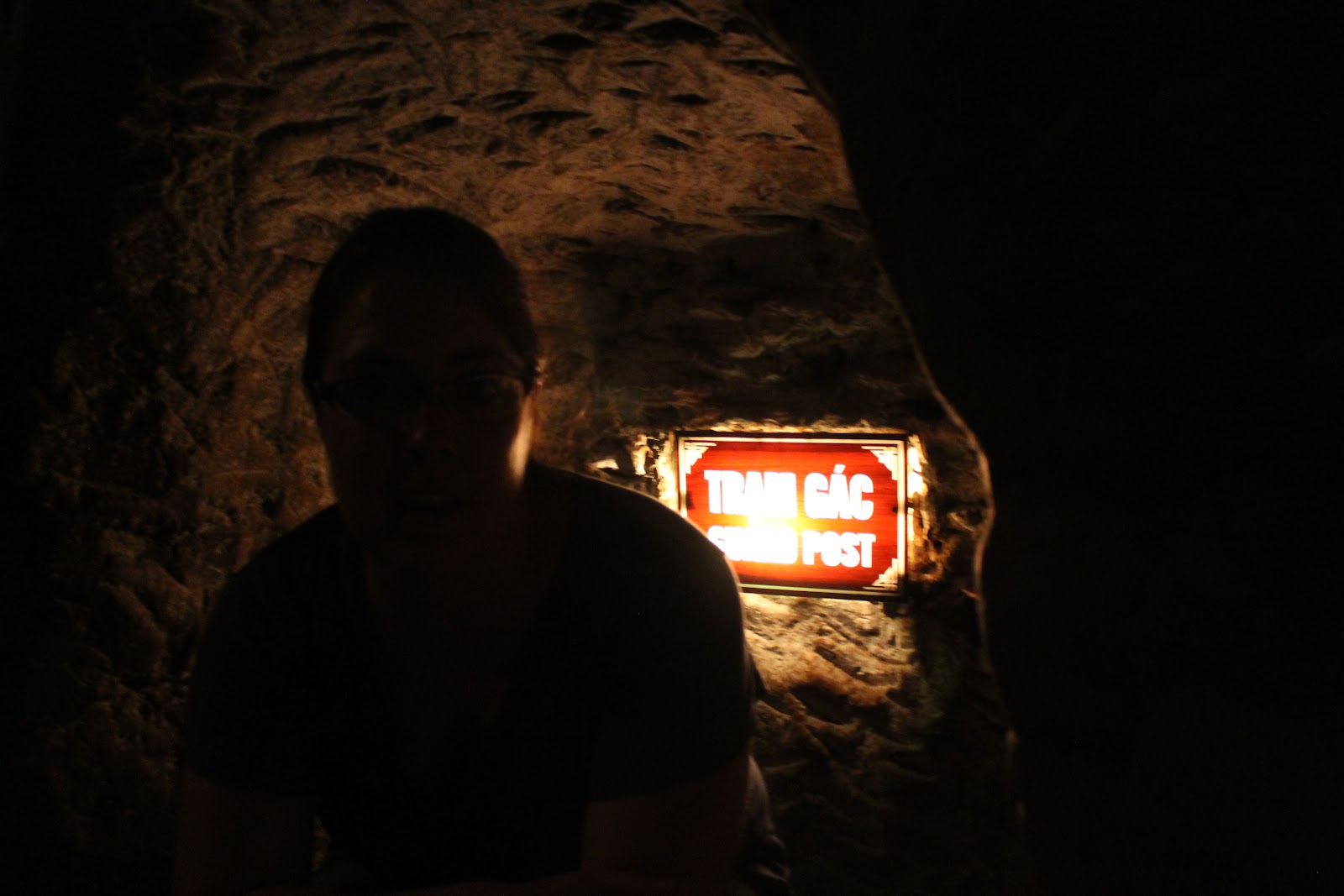
This is me, sitting in one of the guard post spots dug into the wall of the tunnel. Our guide said that someone was stationed there at all times with an AK-47:
More hunched over tunnel shots:

These statues show one of the family "homes" dug into the tunnels... basically a skinny cave barely bigger than a twin sized bed and maybe only 4 feet high. The photo below depicts the "maternity ward" where the 17 babies were born underground:


Tim and our guide, tunneling:


The light at the end of the tunnel:


The tunnels opened out to the South China sea on one side:


No comments:
Post a Comment
Note: Only a member of this blog may post a comment.